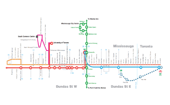
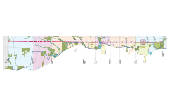
Share:

Mississauga is committed to building a city of the 21st century. We do this by investing in our buildings, transportation, transit, open spaces and public places. This results in a city that continues to provide efficient, cost-effective and accessible facilities, programs and services to meet the evolving needs of its community.  

The City of Mississauga currently owns approximately $9.9 billion worth of infrastructure. This includes roads, bridges, transit, parks, trails and community centres. It’s what makes our economy run, connects our communities, creates jobs, and makes Mississauga an attractive destination for business and talent.

Smart Digital Technology

SMRTCTY-small-background

“A Smart City is the effective integration of physical, digital and human systems in the built environment to deliver sustainable, prosperous and inclusive future for its citizens” – British Standards Institute (BSI)

Creating a Connected City

Mississauga is home to the largest municipally owned fibre optic network in Canada. Over 800 kilometres (497 miles) of fibre connect over 290+ sites across the city.

A Virtual City Campus

Mississauga is the first Canadian city to make eduroam available to its student population, creating a virtual campus using the City’s free public Wi-Fi network.

Mobile and Digital Transformation

Mississauga prides itself on our online service delivery such as tax self-service, license renewals and recreational program registration.

Fostering Digital Inclusion

Mississauga offers free wireless internet access in community facilitates and public spaces, with many more locations under review.

For Mississauga, a Smart City is one that uses technology to support the people that live, work and play in Mississauga. This includes digital initiatives such as Wireless Mississauga (free public Wi-Fi); digital services through the city’s website, apps and other platforms; computer access and Maker Spaces at our libraries; and many other tools and services.

As a young city, Mississauga has had an opportunity to build technology into our infrastructure, systems and processes in tandem with the rise of digital technology in our society. We also value the social, cultural and economic implications of digital technologies and how they shape our communities. In Mississauga, Smart City technologies will be used to support a better quality of life.

As one of the first cities globally and the first city in Canada to be certified as a Smart City Early Adopter – ISO 37122, Mississauga will continue to prioritize the importance of standardized, globally comparable and independently verified city data.

City of Mississauga Smart City Master Plan, 2019

Airport – Pearson International (YYZ)

#1

Largest Airport in Canada

#1

Busiest Airport in Canada

airport-post

Great cities rely on their airports to connect them to the world. Airports are recognized as economic catalysts for the communities they serve, delivering jobs and investments to the local municipalities. The impact of international airports is even greater; they provide links to global markets while fostering trade, investment and tourism.

Mississauga is home to Canada’s largest airport. Serving over 49 million passengers annually, Toronto Pearson International Airport (Pearson Airport) is a major global hub, providing Canadians with a gateway to the world. With over 330,000 surrounding jobs, the airport is home to the second largest employment zone in the country.

Pearson Airport is the fourth-largest global entry point into the U.S. It boasts flights to 210 destinations and more than 22 million trans-border passengers annually. Overall, Pearson Airport ranks second among North American airports for international connectivity.

Access to the World

Over 70% of the world’s economy is in reach with daily, non-stop flights serving 65 airlines and 210 destinations.

Access to Markets

More than 200 million people live within a 90 minute flight catchment area –more than any other region in North America.

Canada's Largest Airport

Serving over 49 million passengers annually, Pearson is a major global hub, providing travellers with a gateway to the world.

Canada's Largest Cargo Airport

Nearly half of all international air cargo leaving or entering Canada passes through Pearson. That's over 535,000 tonnes of cargo annually.

GTAA 2018 Annual Report, 2018 Data & Toronto Pearson International Airport Master Plan 2017-2037

Serviced by

7

Major Highways

Mississauga-Economic-Indicators

As the only city in the Greater Toronto Area (GTA) serviced by seven major highways, Mississauga offers fast, convenient access to major destinations in Canada and the USA. As part of the Toronto Region, Mississauga is interconnected by an extensive road network consisting of 587 kilometres (365 miles) of major provincial highway networks and five municipal highways.

Mississauga as part of the Toronto Region has a congestion level of 30%, according to data from TomTom, based on GPS vehicle tracking. While commute times vary, the overall regional average commute time is 32 minutes, ranking ahead of Washington, DC, and New York.¹

The Queen Elizabeth Way (QEW), is a highway that connects the GTA with the international border at Niagara. The QEW provides entry to the USA at Lewiston, Niagara Falls and Buffalo and passes through Mississauga en route to downtown Toronto.

Highway 409 provides a direct link from Highways 401 and 427 to Toronto Pearson International Airport.

Highway 410 provides a link northwards from Highways 403 and 401 through the City of Mississauga to the City of Brampton. It services a major portion of Mississauga’s industrial area west of Pearson International Airport.

Highway 403 is a multiple lane highway which connects the QEW with Highway 401 and provides an east/west highway link through the centre of Mississauga. There is a convenient interchange at Hurontario St. (Highway 10) with access to the Mississauga City Centre: a major concentration of mixed uses including office, residential, retail and entertainment. Carpool lanes (HOV – High Occupancy Vehicle lanes) are operational on Hwy. 403 allowing vehicles carrying more than one passenger to cut travel times.

Highway 407 is the world’s first all-electronic toll road; a 108 km east-west highway which travels across the northern and western boundaries of Mississauga. This new multi-lane highway spans the northern section of the Greater Toronto Area from Highway 403 in
Burlington to Highway 7 in Oshawa.

Highway 401 is a multi lane highway running from Windsor on the west to the Quebec border on the east. Often called “Ontario’s Main Street”, it is by far the busiest highway in Canada and North America. Running through the Greater Toronto corridor, it is a complex system of express lanes, collector lanes and ramps. Highway 401 passes through Mississauga with six interchanges within the City.

Highway 427 is a north/south highway system linking the City of Toronto with Mississauga and areas to the north.

¹ Toronto Global, 2018
All remaining information pulled from City of Mississauga, 2018 Data

Bus & Transit

2nd

Busiest GO Bus Terminal
in Canada

bus

MiWay is the municipal public transport agency serving Mississauga, and responsible to the City’s Transportation and Works Department. In just five years (from 2011 to 2016), MiWay ridership grew by more than 15%. Mississauga has the second highest local transit ridership per capita in the Greater Toronto Area (after Toronto).

Excluding Toronto’s Union Station, Mississauga also generates the most GO Train ridership of any municipality, with 21,000 passengers per day. Most of this ridership is in the peak hours of the morning, moving the equivalent of a six-lane highway. The Square One GO Bus terminal in Mississauga is the busiest bus terminal in the GO Transit network, with more weekday bus departures than any other terminal including Union Station.

MiWay Local, also known as MiLocal is offered to commuters looking for local travel along regular and school routes.

MiWay Express, also known as MiExpress is offered to commuters looking for express travel servicing limited-stop routes. 

The 18-kilometre Mississauga Transitway provides a fast, congestion-free, east-west corridor across the city for bus services. Higher vehicle speeds also create more efficient service, with lower operating costs per passenger. Initial trends indicate the Transitway has been successful at increasing ridership, with MiWay needing to add capacity to accommodate the extra demand.

Mississauga Transportation Master Plan, 2019 & City of Mississauga, 2019 Data

Train & Rail

3

Major Railway Lines

gotrain-torontoandmississauga

GO Transit is a regional public transit system serving Mississauga and the Greater Golden Horseshoe Region of Ontario, Canada. Strategically located within high-density locations and offering on-site parking, GO Train stations in Mississauga conveniently connect the city with the rest of the region.

Intermodal

CN and CP Rail provide intermodal services from terminals in surrounding cities. Clients may deal with rail companies to pick up a container or a conventional truck load for shipment.

Passenger

Intercity and long distance rail passenger service is provided by VIA Rail Canada and AMTRAK. Commuter service is offered by GO Transit throughout the Greater Toronto Area on all rail lines.

City of Mississauga, 2019 Data

454 km

Total Cycling Network

cycling

The City of Mississauga initiated a project in 2017 to update the 2010 Cycling Master Plan. Evolving best practices in cycling infrastructure design and new thinking on network planning principles necessitated the update of the plan. This work is now completed and the resulting 2018 Cycling Master Plan presents how it was developed, its findings and refreshed goals, its recommended cycling network and supporting programs, and its recommended implementation and monitoring plans.

Cycling Network

The City envisions a comfortable, connected and convenient cycling network that includes separated bike lanes, cycle tracks, multi-use trails, conventional bike lanes and shared routes.

Supporting Programs

Bicycle parking, sharing and education is an important part of a connected, convenient and comfortable cycling network and a bicycle-friendly city. The City will support these three initiatives moving forward.

City of Mississauga Cycling Master Plan, 2018

Upcoming Developments

Infrastructure funding investments are important and help us build strong, vibrant and connected communities. Here is a list of upcoming developments you can expect to see in Mississauga:

Hurontario Light Rail Transit (LRT)

With the new 18-kilometre (11 miles) Hurontario LRT, which will be named the Hazel McCallion Line when it becomes operational in Fall 2024, will benefit communities across Mississauga and Brampton. Residents will find better, more convenient ways in which to live, work and play. As each city expands with new residents, businesses and amenities, frequent and reliable transit becomes vital — giving communities the freedom to choose where they want to go, when they want to go. With 19 stops and its own dedicated lane, the Hazel McCallion Line ensures a smooth, fast, convenient ride between Mississauga and Brampton without the annoying traffic.

2020

Project
Start

2024

Estimated Completion

City of Mississauga & Metrolinx, 2020 Data

Proposed Developments

The City is continuously planning for future growth and this may include adding or expanding City infrastructure projects. We have listed a few planned and proposed developments in Mississauga below. To view the full list of City projects, please click the button above.

Dundas Connects

Dundas Connects is a planned development that aims at supporting major improvements including transportation, road maintenance, land use, new developments and the public realm along the Dundas Corridor. The Dundas Corridor is 4-km (2.4 miles) wide and 17-km (10.5 miles) long, stretching from Oakville in the west, to Toronto in the east.

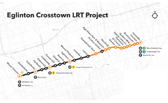
Eglinton Crosstown Light Rail Transit (LRT)

The Eglinton Crosstown is planned development consisting of a light rail transit line that will run along Eglinton Avenue between Mount Dennis (Weston Road) and Kennedy station. It will have up to 25 stations and stops linking to 54 bus routes, 3 subway stations and various GO Transit lines.

Lakeshore Connecting Communities

Lakeshore Connecting Communities is planned development aimed at preparing for future growth of Lakeshore Road. It includes the development of policies and guiding principles around future developments for the Lakeshore Corridor. It will also plan for the better use of existing roads to move people and goods.

City of Mississauga, 2019 Data

Interested in learning more about our infrastructure?

Don’t just hear it from us

Paul, Ellen, Carl & Uli

Paul, Ellen, Carl and Uli speak about the benefits of being located in Mississauga including the city’s relationships, quality of life, talent, infrastructure and business community.

Provide feedback on this page
Report a problem or mistake on this page